The problem
Highways objections are one of the most common reasons planning applications fail. The local highway authority must be satisfied that a site can be accessed safely, that parking provision is adequate, and that the development will not create unacceptable traffic impacts. If these points cannot be demonstrated clearly, applications face delay or refusal regardless of the wider proposal.
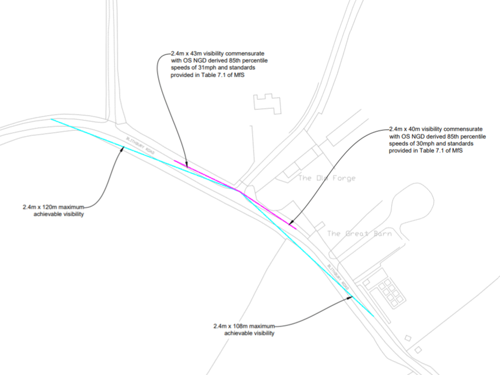
One of the standard highways objections on rural sites is visibility. I’m involved in a lot of sites where this comes up, but to take one example. The road is posted at 60mph, the required visibility splays are not achievable to that standard, and the highways officer is concerned whether the access is acceptable at all.
The solution
The usual next step is a request for an Automatic Traffic Count (ATC) survey, with the extra cost and delay that comes with it. But can that sometimes be avoided with clever use of open data?
Instead of going straight to a surveyor, I looked at the estimated speeds using the OS National Geographic Database (NGD). This is an actively developed set of open data provided by OS. It includes a variety of useful geographic data, and particular to this problem, average speeds.
The achievable visibility did not meet the splay associated with the posted speed limit, but it was more than sufficient for the speeds indicated by the NGD data.
Highways accepted the position and no ATC survey was required.
I would not put that down to the speed data alone. The access had other things going for it and those clearly mattered in the planning balance. But the NGD speeds were an important part of the argument. They helped move the discussion away from the fallback position of “it is a 60mph road, therefore full 215m splays are required”.
What I took from it
It is the first live planning application I have personally dealt with where OS NGD speeds have been accepted in place of a speed survey.
I would not assume every authority will take the same view, and I would certainly not suggest NGD is a universal substitute for an ATC. Context still matters, planning judgement still matters, and some sites will still need survey evidence.
However, it does show that the data can have real value on live projects, not just at feasibility stage.
For smaller schemes in particular, that matters a lot. An ATC is not always a trivial cost, and sometimes it is being suggested before anyone has properly tested whether it is actually a material issue.
Why it matters
The broader point is that open geospatial data is starting to influence live planning decisions in a more meaningful way. Used properly, it can help identify which problems are real, which are being overstated, and where a more proportionate response may be justified.
I now review OS NGD speed data as part of early access and visibility work. On many schemes it will just confirm that a speed survey is still needed. On others, there is the possibility of avoiding unnecessary cost. If you are dealing with a site where visibility may be the main highways issue, this is something I can review at the feasibility stage.